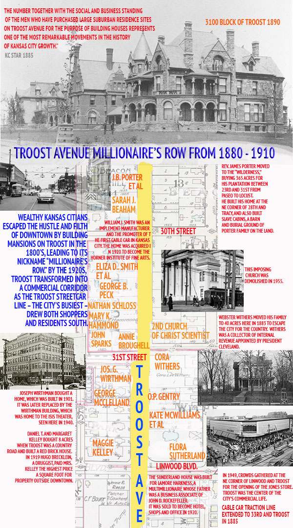
It is history day at the Midtown KC Post, and we’ve got a new map that shows how Troost Avenue changed between 1880 and 1920, transforming from millionaire’s row into Kansas City’s premier shopping street. The best way to see the transition is by studying old maps of 29th to 32nd Streets and Troost.
The map below is based on a 1907 property ownership map of Troost when most of the grand mansions built in the 1880s still stood. You will notice from the names of the property owners that the male businessmen had, in many cases, died, and the property was then owned by their wives. By the 1920s, as residents moved south and the Troost streetcar followed, the mansions were replaced by a thriving commercial shopping district where everyone in Kansas City went to find the latest goods.
As part of our Uncovering History Project, the Midtown KC Post is examining each block in Midtown. A set of 1940 tax assessment photos is available for many blocks.
Working at Best Deal gives me the opportunity to see these old buildings up close and personal.
The architecture is wonderful at times and puzzling at others. But you can come see for yourself!
This area is being revitalized, stop in at Best Deal at Linwood & Troost and talk to Ben!
We’ve been here for around 30 years or so. Look at 911 E. Linwood as well! Beautiful
sights can be realized on Troost once again.
Pingback: Do you remember the northeast corner of Linwood and Troost? | Midtown KC Post
Pingback: More Midtown history: Jewish life, millionaires on Troost, early Rockhill | Midtown KC Post
I thought the Jones Store was at 31st & Troost and Firestone was at Linwood & Troost. It’s been years since I’ve lived in that area so I could be mistaken. I thought Operation Breakthrough was located at the old Jones Store on Troost.
Pingback: Home at 30th and Troost housed millionaires and musicians | Midtown KC Post
Pingback: New site focuses on Porter Farm area around 27th and Troost | Midtown KC Post
Pingback: Home at 30th and Troost housed millionaires and musicians - Uncovering History Project