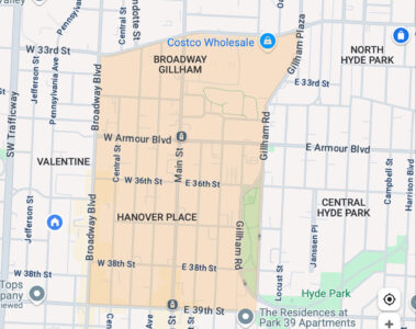
A Google Maps screenshot showing what Google calls the Hanover Place and Broadway Gillham neighborhoods…which we local folks call Old Hyde Park. The orange shading indicates the official boundaries of the Old Hyde Park Historic Distict Neighborhood.
A news story in the Kansas City Star this week discussed a death in the Hanover Place neighborhood. This got my attention because it has been driving me crazy for years that Google Maps refers to a section of Midtown Kansas City as Hanover Place. (It also lists the section of the Old Hyde Park neighborhood as Broadway Gillham, which is an old name for the neighborhood that has not been used by local people for maybe a few decades.)
This explains why the Star sometimes refers to the area as Hanover Place, but not why it is listed that way on the Google map.
The screenshot of Google Maps (above) shows that according to Google, thereis a neighborhood the area between W. Armour and E. 39th Street from Broadway to Gillham Road called Hanover Place. Yet I have never heard anyone in Kansas City refer to the Hanover Plane neighborhood. So where does that neighborhood label come from?
A little research indicates Google Maps gets its information from both official city and commercial sources. It doesn’t look like the Hanover Place name comes from a city source, since the city recognizes the Old Hyde Park Historic District Neighborhood Association as including both Hanover Place and Broadway Gillham.
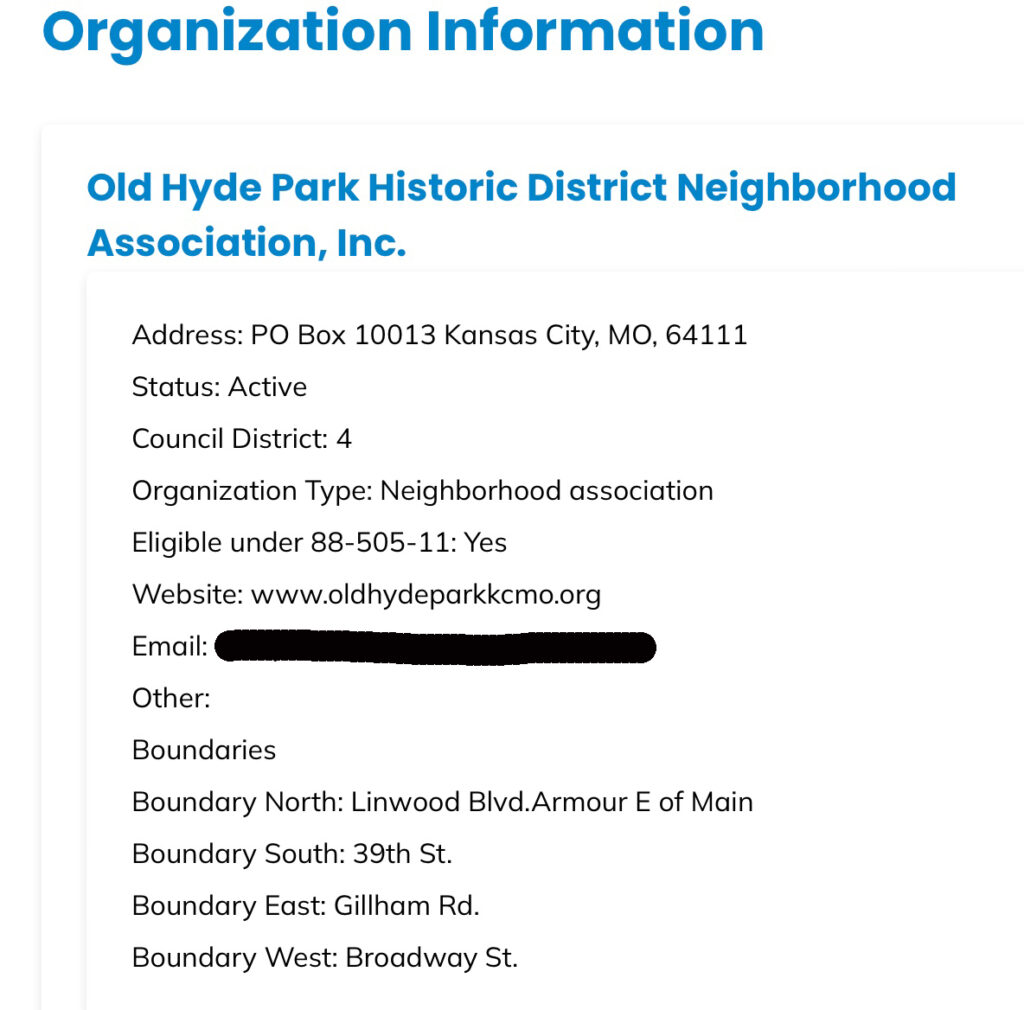
The city’s KC Compass site lists Old Hyde Park as the official name of the area generally between Linwood/Armour, 39th Street, Gillham Road and Broadway.
Several places in other parts of the United States and around the world have been identified by names unknown to the locals.
I started to unravel how this all came about, but then I thought there might be folks out there who already have some insight into this discrepancy. Please share your thoughts in the comments, and we can work together to figure this out.
Questions about Old Hyde Park’s name
Here are the questions:
Do you have any idea why Google Maps refers to Old Hyde Park as Hanover Place?
Does it matter to you?
What do real estate agents call the area?
Is it worth trying to get the map corrected? (I’ve read it is very difficult.)
I can’t speak to where it came from but if you check the city parcel viewer, Hanover Place is listed as the “Census Neighborhood” for properties between Broadway and Gillham & and Armour south to 39th. Properties from 31st to Armour and Broadway to Gillham have Broadway Gillham listed as their Census Neighborhood.
And to follow up, it looks like Hanover Place appears in the KC Star archives in real estate ads back to 1886, and any “Old Hyde Park” mentions start a year or two later, and appear mostly descriptive – lots are “near the old Hyde Park” vs. the area being called Old Hyde Park. The Star archives also include several mentions of the Hanover Place Neighborhood Association in the 1980s, so there was clearly some colloquial shift/rebranding fairly recently. And the name does continue to exist legally!
Katie, that is interesting. I have only been in Kansas City since the early 1980s and have never heard of a Hanover Place Neighborhood Association.
I grew up in that neighborhood, on Central just behind the Colonnade apartments. They tore them and our building down to build a big building. They tore them grounds of the colonnades where so pretty. We used to walk our dogs there and I remember the big Ginko trees as being so stately. My grandmother lived in the Westport Arms and we used to walk up the drive behind there and up over the wall to go to the Parkview drug store. Was all over that area, and we used to go Hyde Park to swing at night sometimes. I remember going to Jack Frost doughnuts in the VFW building to buy a warm doughnut for a nickel. Going to the Uptown for movies. Thanks for a look back at the way things used to be back in the 50’s when I was a kid and you weren’t afraid to go out after dark. I live in Texas now but still have such wonderful memories of that area.
On Parcel Viewer, it appears that “Hanover Place” is a very small plat that is bounded by W 36th St on the north, Wyandotte St on the east, and Broadway Blvd on the west. The southern boundary of the plat cuts between two blocks, along the alignment of Valentine Rd, were it to continue east.
I see on Wikipedia that George Kessler “was engaged to develop a neighborhood park” in the area when it was coming up. Kessler was from Germany so there could be a connection there.
Also looking at the Jackson County Recorder of Deeds, it appears that the plat was recorded September 10, 1886:
https://aumentumweb.jacksongov.org/RealEstate/SearchDetail.aspx