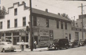
On one block of Westport around 1900, black families lived next to white families, and a church founded by a former slave and his brother stood just down the block from a grocery store in one of the oldest buildings in Kansas City.
The block of Westport from Pennsylvania to Mill between 40th and Westport Road has seen several distinct stages of development. Last week, the Midtown KC Post detailed some of the changes on Pennsylvania Street from the mid-1880s to the early 20th century. Today, we continue our trip around the block along Westport Road and then up Mill Street.
As part of our Uncovering History Project, the Midtown KC Post is examining each block in Midtown. A set of 1940 tax assessment photos is available for many blocks.
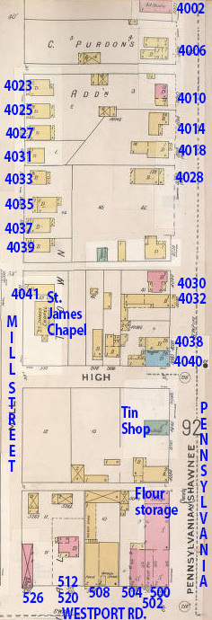
This early map (1895-1907) shows the block before Manor Bakery was built in 1926. The St. James Chapel, a black Baptist Church, stood at 4041 Mill. As the bakery expanded, it moved to West 43rd Street in 1939.
Corner of Pennsylvania and Westport Road: Frontier building survives
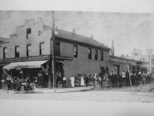
At the corner of Westport Road and Pennsylvania, one of Kansas City’s best-known historic structures still stands. The building that is now Kelly’s Westport Inn has housed a number of different businesses over the years since it was built in 1850-51. Albert Boone bought it in 1864 and ran his trading post there. It was also used as a drug store and a hardware store. In the 1930s, it became the Wrestler’s Inn, known for live wrestling and free-flowing liquor. The building is on the National Register of Historic Places.
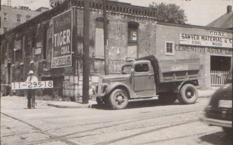
This section of Westport Road also housed several small businesses. As late as 1940, the Sawyer Material Coal Company was operating at 520 Westport Road, at the corner of Mill Street.
From a Racially Mixed Residential Area to a Commercial Block
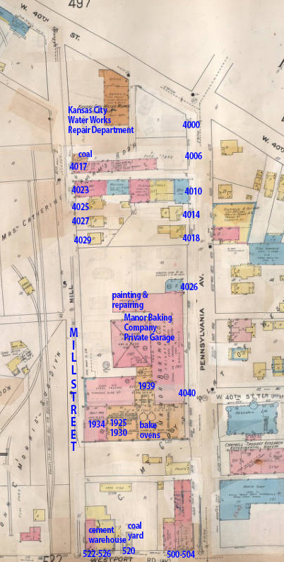
A later map of the block, from 1907 to 1950, shows the expansion of the Manor Baking Company and the Kansas City Water Department and the removal of the St. James Chapel and several of the homes along Mill Street.
While the Kelly’s building has remained, most of the rest of the Mill Street side of this block was transformed in the early 1900s. As the earlier map above shows, Mill Street was lined with a church and several small frame homes in 1895. In the 1920s and 1930, commercial expansion led to the replacement of those homes and the church.
The St. James Baptist Church at 4041 Mill Street was a black Baptist Church started in 1895 by two brothers, one of whom was a former slave. According to a 1998 article in the Kansas City Star, this was the first black Baptist Church in Kansas City, a small wooden-frame building. The church sold its land in 1939 to allow the Manor Baking Company to expand. It moved to West 43 Street.
The row of small frame homes along Mill Street, all gone now, was occupied by both black and white families in records from the 1910 and 1920 censuses. Black minster John Williams lived at 4043 Mill in 1910, alongside white restauranteur Elmer and his wife Margaret Potter at 4037; white city water department tapper Michael Cushing, his wife, two sons, a daughter, and father-in-law at 4035; and white letter carrier Moses Lemos and his wife Laura, two daughters, and brother-in-law Edgar Mashburn, a bank bookkeeper, at 4033.

At the north end of Mill Street on this block, the city water department operated a facility.
Historic photos courtesy Kansas City Public Library/Missouri Valley Special Collections.
Mary Jo,
Thanks for finding all this information about Westport and about the families (white and black) living side by side and all the information about the businesses in Kelly’s building and all the businesses and homes Westport Rd, Mill Street, and Pennsylvania Street.
So very interesting!
Sharon Smart
Pingback: How important is preserving the history and character of Westport? | Midtown KC Post
Mary Jo, I live in the area right off Broadway and Armour Blvd and I know that before it was annexed by the city, it was technically a part of Westport. The first tall apartment building on the Southwest end of West Armour has the name of Westport Central. Does the 450 buildings in the survey cover this area as well?
Thanks,
Brad
Brad:
The boundaries are Southwest Trafficway to Main, 39th to 43rd so Armour would not be included.
Mary Jo
This is so interesting!!! I live on Warwick & 43rd by the KC Art Institute and we go to Westport all the time. So interesting to see the history of these wonderful old buildings and happy that a lot of them are still around today.
Thank you for all these great articles!
This is a great Irish landmark!
Question: What about Hunt brothers 502 Westport road, owned by my great grandfather J.W.Hunt and his sons around 1887-1940 when the building burnt down. Also J.W. was an original stockholder in Westport Bank, any way to verify that? I believe a lot of the family records lost in the fire.