

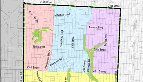
The North East sub area of the Midtown/Plaza area plan is the area in purple.
If the Midtown/Plaza area plan’s recommendations become a reality, traditional strip development on Troost Avenue will be replaced by mixed use development. New businesses will provide neighborhood-oriented services, and their storefronts will face the street with parking in the rear or on the side.
 Those are among the concepts in the area plan’s specific recommendations for the North East sub area, from 31st to 43rd Streets, from Gillham Road to the Paseo.
The plan contains overall recommendations for the area from 31st to 55th Streets, from State Line to the Paseo. It also breaks down the Midtown/Plaza area into four sub areas, including the North East sub area, with detailed recommendations for land use in each one.
Following two open house meetings last week, city planners are using feedback to refine the Midtown/Plaza Area plan into a final draft. The plan, developed with input from the public, will become the city’s long-term vision for the future and provide a comprehensive framework to guide public decisions on land use, housing, public improvements, community development and city services.
This week, the Midtown KC Post is sharing some of the recommendations in the draft plan for each sub area, continuing today with the North East sub area.
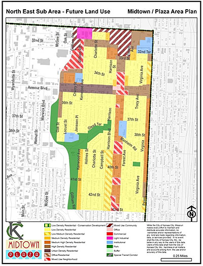
The map (above) shows the recommended land use for this sub area. According to the plan, the land use map prescribes where specific land use types and densities should be located.
The North East Sub Area is predominately a residential area. The 31st Street, Linwood Blvd, and Troost Corridors are commercial corridors within the area, that could be enhanced and benefit from reinvestment. Armour Boulevard in this sub area and the North Central Sub Area has seen significant reinvestment in multi-family housing over the past few years. There is a strong desire to see this reinvestment continue and spread further within the sub area.
For larger versions of the maps, download the full PDF of the area plan below.
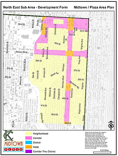
The plan also contains a development form map, which planners use to describe how the built environment should look and feel, independent of land use (right).
In addition, the plan contains some recommendations for this sub area.
Planning Recommendations
- Commercial encroachment into existing residential neighborhoods shall be discouraged. Any development adjacent to a residential neighborhood shall provide a transition element to that neighborhood as consistent with this plan’s development form guidelines.
- Developments that are designated as nodes within the plan’s development form guidelines should be oriented so their fronts address the street and are brought up to the street with parking in the rear or to the side. The plan supports neighborhood oriented commercial uses at these sites while maintaining existing residential boundaries.
- The redevelopment of vacant properties should adhere to the historic, pedestrian friendly layout of the area and be developed to be consistent with the recommendations of the plan’s Recommended Land Use and Development Form Guidelines.
- Address the triple bottom line issues of equity, economy and the environment, and work with the community to determine the best strategic short-term and long-term recommendations for creating a sustainable development projects within the corridor.
- In order to encourage quality development, organizations within the entire North East Sub Area should work to develop zoning overlay districts that implement the plan’s recommended land use and development form guideline recommendations.
- Mixed use development on Commercial Corridors between the nodes shall contain neighborhood oriented service activities and/or multi-family residential uses. Regional commercial developments shall not be encouraged.
- Any property that requires a rezoning or receives tax incentives shall be rezoned to a planned zoning district shall be subject to the plan’s Development Form Guidelines.
Specific Recommendations
- Traditional strip commercial development on Troost Avenue shall be discouraged and replaced by a mixed use pattern of development along the mixed-use corridor. Nodal mixed use development shall occur at major intersections.
- Any future development/redevelopment project should be consistent with the policies of the Troost Corridor Redevelopment Plan adopted in 2014 and the Troost/Emanuel Cleaver II Boulevard Redevelopment and Implementation Plan, adopted in 2015. The recommendations within this plan are consistent with area plan recommendations, but presented at a more detailed level.

Who’s talking